February 9, 2020 at about 9:30 PM
We’ve started watching the weather for a couple reasons: getting to Australia next month and maybe getting out for a short, local cruise before that. Tonight, the two models we look at are WAY out of sync. Here there are side by side – from PredictWind…
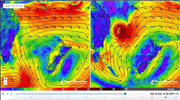
On the left is PredictWind’s PWG model and on the right is the ECMWF model. Both are usually very good. Here, ECMWF shows a cyclone that passes over the northern tip of New Caledonia and on Saturday, has dropped south off the coast of Australia. PWG shows the low above New Cal for a bit and then it dissipates.
This is both educational and uncharacteristically fun for us to watch. We can observe without the usually stress of having to pick weather for an imminent passage. It’ll be interesting to see what really happens with this low or cyclone. I’ll try to remember to post an update here with the results. -Rich
Update, February 13, 2020 (4 days later)
Below are PWG and ECMWF as they appear now. It looks like ECMWF is the winner, at least so far. The PredictWind models are now showing the cyclone pretty much as ECMWF (and GFS) did four days ago.

Update, February 15, 2020:
Well, it moved just a little faster than ECMWF forecast, but it’s clear that they are the winner. The cyclone remnants are pretty close to where ECMWF said it would be six days ago. Even PWG has come around and today looks almost exactly like ECMWF.

I think that reinforces what we’ve thought: ECMWF is the best the furthest out and for open-ocean conditions. I’ll continue to look at PWG for a second opinion and especially in areas close to land as I think they model land effects better than the other models.
This concludes this test of the emergency weather forecasting system.
Update: February 17, 2020
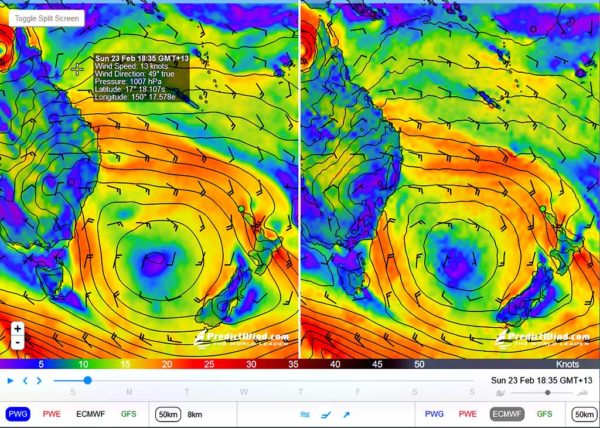
We’re looking at a (remotely) possible weather window to sail to Oz on Sunday. Again, PWG and ECMWF couldn’t be much more opposite. I’m going to continue this story here over the next few days and we’ll see who’s right. Here’s today’s picture:

It seems that ECMWF is winning this one as well. Here’s what it’s showing 3 days later with both models now agreeing on a high pressure system in the Tasman on Sunday.
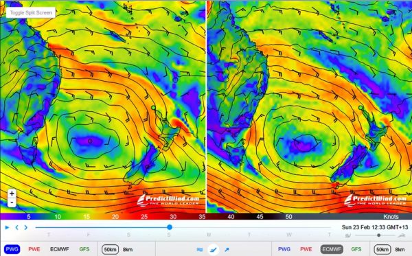
And here’s the final result… ECMWF wins again. PWG used to be my go-to model but lately, at least in the Tasman, it’s often getting it wrong. I wonder what’s up? -Rich