
February 27, 2016
Here’s how it went.
Lets see… We need to get to Napier, 280 miles away. We need to get there in daylight. We need to get there before the wind picks up. We’ve got to get around East Cape while the winds are westerly or northerly. We can’t get out of our berth when the tide is running. When’s slack tide? Shall we stop along the way? Where? How many stops?
That’s as far as I got before my head exploded. Brainy bits all over the place. The explosion was caused, in part, by trying to keep track of distances and the times it would take to cover those distances. Enter these tables…
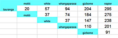
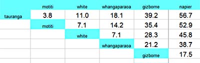
While not 100% accurate due to the extra time and distance entering and leaving anchorages at the various destinations, it was good enough and a real help in planning. I think I’ll make these more often. -Rich


