
October 19, 2019
A few days ago we heard that a yacht bound from Fiji to New Zealand was lost and there was one fatality (out of the crew of four). This isn’t something I intended to write about. I think Cyndi’s done a more-than-adequate job with the doom and gloom lately 😉 but then I read a comment about the situation on Cruising Anarchy that pushed me over the edge:
For those wondering what they were doing out there, I think it has been answered. The conditions were bad and forecast but how quick those systems develop and move is pretty hard to know in advance, most models contradict each other until 3 or 4 days out around here.
Weather and seas like that are not particularly unusual here and especially on the trip they were making. If your used to staying home if the forecast says over 25, don’t bother coming to NZ you will never leave your mooring.
Oh, were do I start! Pretty hard to know how quickly these systems move?!
Let me pontificate based on our now nine trips between the tropics and New Zealand (and an additional four trips between the tropics and Australia). I speak only 0f our experience and don’t claim that any of our techniques are right for anyone else.
Yes, the weather forecast files we get (GRIB files) aren’t 100% accurate, but they get more and more accurate as the forecast period shortens. Certainly a day or even two before the tragedy, the models would have accurately indicated the position and movement of the low. On Legacy, we get weather files every day while at sea and sometimes even twice a day. We also use a professional weather router (Bob McDavitt). Had we seen this coming, we would have hove-to or changed course to avoid the system – even if that meant heading back towards Fiji or Minerva.
Yes, the various weather models contradict each other at times, but that’s no cause to ignore all of them! That’s cause to be even more cautious when planning a passage. You can’t just hope for the most pleasant forecast model to be the accurate one. We always plan for the worst-case forecast to be the way events unfold.
The above blowhard states that weather like this isn’t unusual for this passage. While it’s true it isn’t “unusual,” there are ALWAYS periods of suitable weather. Sometimes you have to wait a long time for them. Three years ago, we waited a month for good weather for a passage before we gave up and sailed from Nelson to North Island, New Zealand instead of New Caledonia. Once in the Bay of Islands, we waited another month to get a weather window we considered reasonable. That’s just what it takes sometimes.
Waiting like that isn’t possible if you have a schedule and while I really know nothing about what actually went on during this ill-fated voyage, I suspect we’ll find out that a schedule was behind the sinking. This is really not the time of year to make this passage and good weather that lasts long enough is rare. Remember the old sailors poem about when to sail from the Islands to New Zealand (that Cyndi just made up):
If the month starts with an ‘O’, just don’t go.
If it starts with an ‘N’, think again.
If it starts with a ‘D’, it’s time to flee!
If you stay home if the forecast is for 25 knots, you’ll never leave the mooring! Hah. It wasn’t 25 knots that killed this man. It was gusts that may have reached 60 knots. It’s easy to look at weather models and see 25 knots when there might be much higher and very dangerous gusts. We always look at the gusts on the model as well as what might be fronts or troughs.
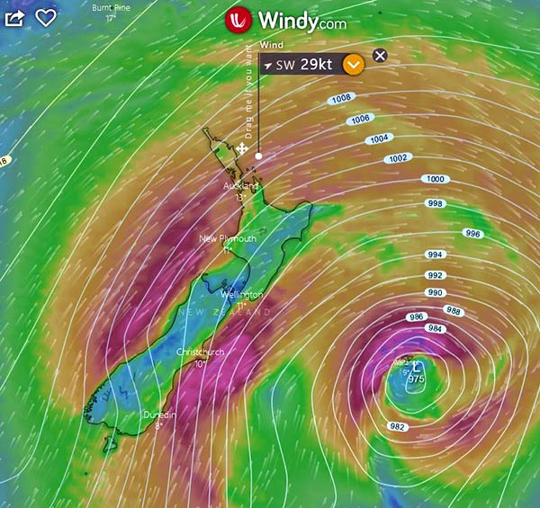
Example: below is a forecast for this coming Thursday on windy.com. It shows wind at 29 knots as you approach NZ.
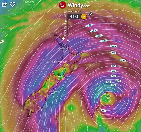
But if you look at windy with the gusts turned on (ECMWF Model), you see that the gusts are 41 knots in that same spot. Pretty bad.
And then we always look at the rain and thunder as this helps highlight fronts and troughs (I’ve marked what looks like a front to me in red):
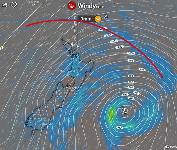
The reason this is so important is that the weather models are notoriously bad at forecasting conditions around these local disturbances. Gusts might be much higher than the forecast value and if so, now we’re probably talking about 60+ knots.
And don’t forget the seas! Here’s the wave prediction for this same area:
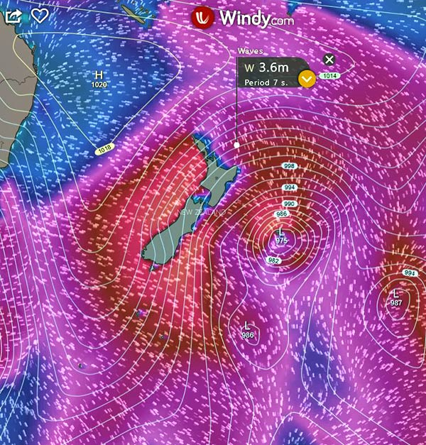
That’s 12-foot waves every seven seconds. Easily the kind of seas that can fatally damage a yacht!
It was easy to find an example of weather like this to illustrate my point. This is what it has looked like all month! This is what it looks like in October. So no, in 25 knots – that might have 40 knot gusts – or 60+ knot gusts in a front, don’t even leave your mooring if you see a forecast like this, even if it’s not on all of the models! -Rich
P.S. The comment that made me so angry was on Sailing Anarchy. I find that almost every time I accidentally look at that site, I get angry. To me, it seems like a bunch of old guys who have no experience telling other old guys with no experience exactly how everything must be.


