
The two island groups off Viti Levu, the Mamanucas and the Yasawas, are quite different in look and feel.
The Mamanucas are much closer to the Viti Levu’s marinas and can be reached in a few hours. They are relatively protected from swells as they are bordered by an extensive reef to the west and the big island of Viti Levu to the east. With a couple of exceptions (such as hilly Malolo Island or ruggedly steep Monuriki and Monu Islands), they are relatively flat with lots of beaches and sparse vegetation (mostly dried grass during the winter). In fact there are quite a few tiny islands, basically circles of sand with some interior vegetation, that feature a resort. The Mamanucas are also the location of Fiji’s biggest cruiser attraction and gathering place: the Musket Cove Resort complex.
At first glance at a chart, it looks like the Mamanucas have so many islands to see! But this is very misleading as in fact, there area only a handful of places that are practical for a cruising boat. This is generally because many islands have either no anchorages, or if they do they aren’t protected and thus require very settled weather (rather a rare occurence) to visit. Some of the resort islands are private so even if you could manage to anchor there, you would not be allowed on shore.
Another factor, important to realize in the Mamanucas, is that while it’s protected for the most part from swells, it still gets windy as heck; so it’s not so easy to travel around as it would seem. Taking into account that there’s a lot to see in Western Fiji and settled weather is often used to travel to make trips to the Yasawas, surprisingly few cruisers have or take the time to see much of the Mamanucas.
To sum this up, I’ve made map below with the island names written in different colors depending on what category they fall in.
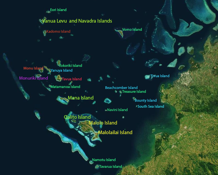
Yellow: This indicates the island that everyone visits: Malolailai (and since it’s attached I’ve included Malolo even though few people actually go there). Malolailai is where the famous Musket Cove Island Resort is located. You’ll notice that these two islands are the only ones titled in yellow which means, yep, this is the only area in the Mamanucas where everyone goes.
Light Yellow-Green: I have used this color for islands that are sometimes (but not always) visited by cruisers. You’ll notice Mana Island, while interesting to visit, does require winding through a reef to get into its lagoon, something which puts off many cruisers. Then to the north there’s the connected Navadra and Vanua Levu Islands, beautiful but unfortunately near an area of reef that lets in a westerly swell so it’s often quite rolly in spite of otherwise calm conditions. Finally, I’ve put little Qalito (aka Castaway) Island, very close to Malolo. I put it in this category even though it’s actually a private resort island. Why? Because a few cruisers like to stop in at their upstairs pizza restaurant. You might need to call and get permission because they are sometimes too booked up with guests to allow outside visitors. And going to eat there does not include an invitation to bask on their beach as it’s reserved for guests (although maybe this varies depending on how booked up they are).
Purple: I have used this for a seldom visited place, Monuriki, the island used in the movie Castaway (and often referred to as Tom Hanks Island) and currently used for the American version of Survivor. It’s a beautiful spot but is out of the way and requires settled weather to visit. Anchoring is a bit difficult; so all combined it takes some determination to to visit this place. (We visited and loved it, but only stayed for a night.)
Dark Green: These are private resort islands that mostly have no anchorages, but even if you did mange to anchor you probably wouldn’t be welcome ashore (although there are a couple that we hope to investigate further in 2018–sometimes it pays to ask).
There are a couple of islands I’ll note: Namotu and Tavarua, each of which has a famous surf resort meant for guests who come from around the world to surf nearby Cloud Break (plus other nearby surf breaks). Occasionally, in settled weather, a few cruisers venture down and anchor off one of the islands, then take their dinghy to one of the breaks to watch the surfing action (or even surf themselves). These resorts do not accept visitors, but we’ve anchored off both of these islands and neither resort seemed to mind.
Blue: These are what I call the Day Tripper islands. While they have rather rustic accommodations for the budget travelers (mostly young backpackers so they can get pretty festive in the evening), much of their business comes from the daily stream of excursion boats from Denerau to bring people for an afternoon of swimming and lunch on one of these islands. For the most part, these islands are of little interest to cruisers. While it’s probably possible to anchor off all of them, it would require settled weather.
We finally did get to one of them, Bounty Island, and were shocked to find there’s a landing fee: $175FD per person. (No, that’s not a typo; that’s the actual amount.) It included an “anchoring fee” and a $50FD drink voucher for the bar. Not surprisingly, we found that price outrageous and decided to leave. We later tried to visit the other islands to see if they, too, had landing fees, but the anchorages weren’t good and the seas too rolly on that particular day. Our guess: if one has a landing fee, they probably all do.
There is one island further north, Yanuya, that I’ve put in this category because it’s frequently visited by a charter sailboat that brings people there to visit the village. As far as a private boat visiting, I don’t know the rules but imagine you’d be welcome if you treat it like any other village and do a sevusevu.
Dark Red-Brown: This area islands with no anchorages (at least that we know of).
Red: I put one island here, Tavua, simple because I really don’t know anything about it. It’s definitely not on the beaten path and I’ve never heard of anyone going here, but that doesn’t mean it doesn’t happen. Looking at it on Google Maps, I can see there might be an anchorage on the east side. The west side and its village look like there’s far too much coral and reef for comfort.
Note: There is a small unnamed island just east of Tavua that, if memory serves, is owned and used by a company for private functions (such as dropping couples off for a romantic day of having an island to themselves).