Simrad ForwardScan Sonar vs. Bombie

December 2, 2017

We are out playing with our new equipment (and enjoying New Caledonia) while we wait for weather to sail to New Zealand. One of our new toys is ForwardScan sonar. Below is a short video that shows a coral bombie that wasn’t all that visible to the naked eye (the video has been enhanced to show the bombie better than it appeared in real life).

This was only our second outing with the sonar but I’m really happy with it.

Completing the new equipment one-two punch is the ability to display satellite charts, made from SASPlanet and Insight Map Creator, directly on the chartplotter. (I’ll post a how-to video soon. It’s been a steep learning curve but I think I’ve finally got it down.) Goodbye anchoring stress! -Rich

The Holy Grail

November 29, 2017

About a week ago, we wrote about the New Toys we were installing on Legacy – new chartplotters to replace our older, failing plotters along with forward looking sonar. One of the new units arrived defective and while we’re waiting for the replacement, I’ve been trying to get a feature working that I’ve wanted for so long: Satellite images displayed on the chartplotter for navigation! I’m getting there. See…

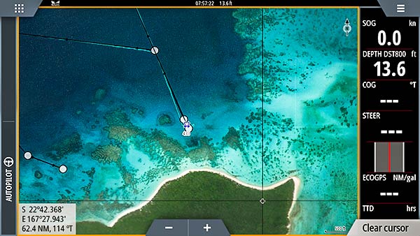
You can even view both the satellite image and chart (Navionics in this case) simultaneously…

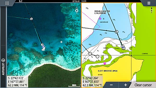
And it’s not just viewing these charts that’s the holy grail for me. I could always do that on my tablet, but it’s being able to use the satellite image directly for  navigation with routes, waypoints and the boat’s position displayed directly on the satellite image.

The other huge advantage is that almost all tablet displays are terrible outdoors. Our hew Simrad NSS9 EVO3 plotters have a beautifully bright screen that is so easy to see, even in direct sunlight.

Insight Map Creator

To make this possible, I’m using a free program called Insight Map Creator (IMC) to create the .at5 files that will display on the plotter. You can find a link to it on our “links” page. It’s been quite a steep learning curve. When I’ve got it figured out, I’ll make a video and post it on our blog.

I’m making charts for New Caledonia right now (since that’s where we are, waiting for suitable weather to get to NZ). Each run of IMC is taking about 20 hours and that’s on our very fast Intel Core i7 laptop. One reason it’s taking so long is that I’ve gotten greedy!

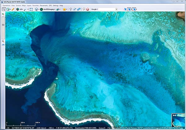
I  used to be happy with simple little .kap files made from GE2KAP or ChartAid. I’d capture a satellite image for an area I might want to anchor or transit and make just a small satellite image of that area. Enter SASPlanet and ESRI ArcGIS.imagery. These satellite images are stunning in their clarity and detail, at least here in New Caledonia and several other places I’ve viewed. Since I’ve seen these images, and since I can  now load them on my chartplotter, I WANT IT ALL!

I’ve made charts for the bottom half of New Cal and it takes up about 30GB on my 32GB micro-SD card. (Good thing they’re cheap. I can just buy them by the dozen and swap them in and out of my chartplotter as needed.) These images are so much better than the .kap files I used to make. For one thing, the ArcGIS imagery is better than what I’ve used before, but also, there is greater color resolution when doing things this way.

Normally, the .kap files have 8 bit color and a lot of detail is or can be lost because of this low level of color resolution. While I don’t know exactly what the color depth is in the resulting .at5 files, it looks stunning. There is so much detail I think I might be able to see individual seacucumbers on the bottom!

Satellite Images as Art

Some of these images are so beautiful, I’d mount them on wall (if I  had walls, that is). See this one below. Again, it’s the ESRI ArcGIS.imagery displayed in SASPlanet.

Zooming in shows the amazing details made by centuries of water flow into and out of the reefs.

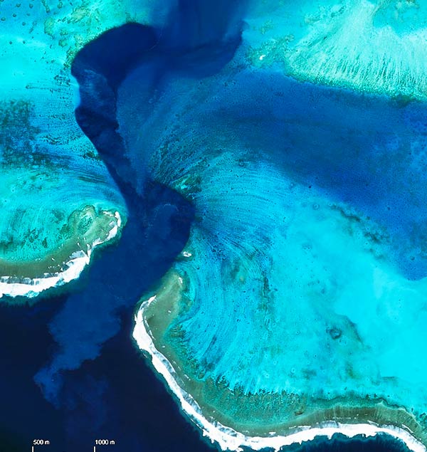
Can you blame me for my greed? I may never anchor here, nor transit this channel, but damn it, I still want the image on my chartplotter! -Rich


New Toys

November 21, 2017

While we’ve been sightseeing and enjoying all the wonderful restaurants in Noumea, we’ve also been busy with boat projects, too. Our Simrad NSE8 chartplotters have been a problem for a while. On the way to New Caledonia from Vanuatu, we couldn’t get the inside one to boot and the outside one was getting more and more sluggish.

When we were here earlier this year, we talked to Thomas at Altomarine about our issues. He’s the Navico dealer here (Simrad, Lowrance and B&G). While our Simrad units were well out of warranty, some of the issues we were having were known to Simrad and he was able to get them to offer us a greatly reduced price for replacement units. Since they don’t make our NSE chartplotters any longer, we got their newest tech – NSS EVO3 units. And since that newest tech supports forward looking sonar, we added that as well. That entailed a transducer change so we had to haul out briefly.

We managed to get the old transducers drilled out and the new ones installed in an hour. The cost at the yard here was minimal and the staff was extremely skilled and professional.

Our new forward looking sonar transducer installed.

The transducer in the center of the hull, the one that sticks down a bit, is the new forward looking sonar. We kept our old transducer as well as it has a boat speed paddle wheel. We moved that off to the side a bit where we had a blank from a previous instrument package.

“Why are they blue?”

Good question. That just happens to be the color of the brushfull of bottom paint we managed to beg and borrow from another boat on the hard. We hope the fish don’t mind the lack of color coordination.

Test Drive

Legacy anchored amongst the bombies.

We got out for a very short cruise to some of the islands and reefs near Noumea. This turned out to be a great test of our sonar. In the above picture, we were anchored in 12 feet of water with coral and rocks all around us. The sonar gave me great confidence traveling in this skinny water.

For us, there are always those dark patches of water up ahead that we don’t know about. Can we pass over it? Is it grass, or is it a rock? I was able to drive right over one of those because the sonar showed the water above the dark patch was more than deep enough for us. -Rich

Here are some links with more details about what we installed…

Simrad NSS EVO3 Chartplotter

Simrad ForwardScan Sonar

ForwardScan Video

P.S. Simrad really came through and Thomas at Altomarine in Noumea is great!

Despite the age of our NSE units, Simrad really stepped up in offering us a very large discount on new units. They really stand behind their products. Thanks Simrad!

Thomas at Altomarine is one of the best marine electronics guys I’ve ever had the pleasure of working with. He went out of his way to make this deal happen for us and supported us all through the process. Thanks Thomas!

The Perfect Ditch Bag

For when things go wrong…

November 12, 2017

We saw this today at the wine store. It holds a box of wine and up to six real glass glasses (be sure to purchase two if you are likely to have more than six people in your life raft).

We can probably accept some compromises when things have gotten bad enough to get into the life raft – box wine is probably OK – but never plastic wine glasses!

OK, maybe that’s not what they had in mind for this product. Maybe that’s just how we roll. -Rich

Cool! (New Caledonia)

November 5, 2017

Back in the land of columnar pines!

Well not really cool, but certainly not as hot as it got in Vanuatu a few days before we sailed here to New Caledonia. Just before we left Vanuatu, we were having trouble sleeping because it was too warm. Last night, Cyndi got out the blanket! What a difference.

The 295 mile trip took us just over 2 days. Conditions were great, and while we mostly motored in light wind, we did get some nice periods where we were able to sail. The last four hours were a bit of a different story.

New Caledonia can be a difficult country to get into: not because of the customs paperwork or quarantine inspections, but because of the Havannah Pass. The huge lagoon fills and drains partly through this pass. We had almost five knots of current, reaching out to sea four miles.

We tried to time our arrival at the pass for slack water at low tide. We thought we’d have to kill about four hours to get the timing right. It turns out that we just kept motoring towards the pass and the current took care of the time we needed to kill. We got to the pass right at low tide but the current was still flowing out at three knots.

Anyway, it was worth all the effort to get through the pass and we’re really glad to be back in New Cal (though sad to have left Vanuatu). We’ll hang out here for a couple of weeks, get a little cruising in, and then sail to New Zealand for cyclone season. -Rich