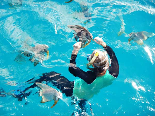
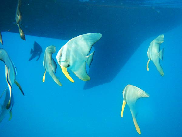
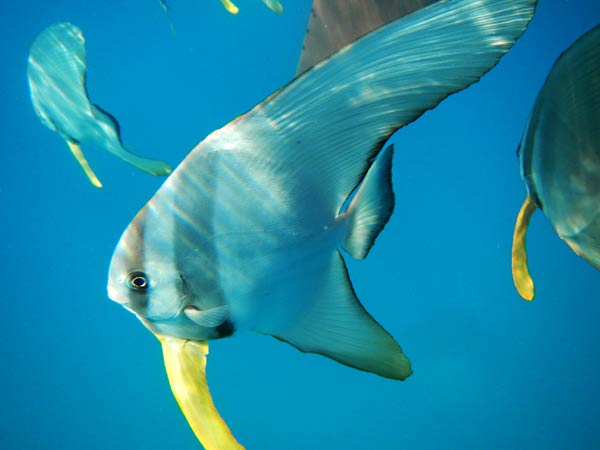
I wanted to go for a swim and see the fish that had been swimming with our friend Sabina. We took our dinghy over to Local Talent, and the fish were still under their boat. I got in and brought out the cracker crumbs, and soon I was surrounded by these beautiful fish that looked like giant angel fish (about the size of my head). They were eating out of my hand, swimming right in front of me and occasionally letting me run my hand along their fins.
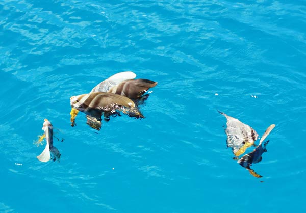
After I finished feeding and swimming with them, I decided I’d swim back to our boat while Rich took the dinghy. The fish completely surrounded me as I went, not following me or looking for food but just swimming with me, almost like they were escorting me back to our boat. When we arrived, Rich had some string cheese ready to feed them, and they went crazy for that! They stayed by our boat after that. (We’ve found a little string cheese can buy a lot of loyalty from many of Earth’s creatures).
The next day we went in to clean the bottom of the boat, with Rich using the scuba tank to clean the lower areas while I worked up higher. Some of the fish stayed with Rich, and some swam by me. They don’t get in the way; they simply hover around like faithful dogs as though they enjoy just being near you and seeing what you’re up to. They have this sort of soothing, peaceful effect, and we found them absolutely charming. That might seem like a strange word to use to describe fish, but these were special fish.
We consulted our Reef Fish guide and found out our new little friends were Longfin Spadefish, and that they are found between Africa and Japan. I don’t know how they found their way to this bay in Tonga, but we sure enjoyed them. They are a big part of the magic of anchorage #11 (Ano Beach and Tapana). -Cyndi
Me feeding the fish in the water.Being watched as we worked on the bottom of the boat (and a view under Legacy’s skirt at here keel!).They were close enough to pet at times.Rushing over to see what I’d clean next.Spadefish enjoying food thrown to them from above the water.
After a peaceful night in Port Maurelle, we were quite contented to just stay there. But as so often happens in cruising, a friend will reach out and get you moving again.
We called our friends on Bright Angel to see where they were, and Bob told us about this wonderful bay they were in, #11. He urged us to come on over as it’s very protected, has room, and is well worth seeing. He told us our friends on Local Talent had just arrived, and that if we came over, we could all have dinner at the nearby Spanish restaurant. (We had heard the restaurant’s amazing, and there was a little floating houseboat art gallery I wanted to see, too.)
All this was too good an offer to refuse; so in spite of the wind, we pulled up our anchor and headed out for the motoring trip to Ano Beach/Tapana Island (#11). Ano Beach is actually on the same island as Neiafu, about a half hour away by car. Tapana is an island just off the end of the point, separated by a very shallow channel about 100 ft in width.
The trip over was windy with occasional splashes of water into the cockpit. We didn’t even bother to put up the sail as the wind was right on the nose! We made it in about 2 hours, and the wind died off as we entered this very sheltered bay. We were back in a calm, peaceful world again, and this place just seemed magical.
After we picked up a mooring, we got into our dinghy and headed over to see our friends on Local Talent. Sabina was swimming and cavorting with these big beautiful fish. She had fed them, and the fish responded by staying with her and even letting her touch them. We also went to visit the Ark Gallery, a floating houseboat the artist Sheri and her husband, Larry, live on and use as a gallery to display and sell her paintings and prints. Her work is beautiful and it would be very difficult to leave her place empty-handed. I ended up buying a small painting for our boat, and I treasure it.
When we headed back to our boat we had a sighting of Missy, the local sea turtle. Already it had been well worth the effort to come here, and in the coming days it would become one of our favorite places in the South Pacific. -Cyndi
Ano beach and the north end of the anchorge.Local Talent on a mooring in front of us.The Ark Gallery in front of the point and Tapana Island beyond.The Ark Gallery.The deck of the Ark Gallery where you can tie up your dinghy.Fish swimming off the Ark Gallery.Missy the sea turtle.
We motored into Port Maurelle and, as expected, there were a few boats already there. We managed to find a spot at the south side of the bay, out by the outer edge in about 25 feet of water. The anchor seemed to set OK, but we’d need to dive in and check it to be sure. It was a big relief that after hours of motoring around looking for a spot in 20-knot winds, we were finally somewhere!
Once the engine was off and things were settled, we looked around. I can tell the author of our guidebook why people “crowd in” here: aside from being well-protected, it’s beautiful! It’s a big bay, fronted by a long, white sand beach. Tropical vegetation covers the rocky hills that surround the water, which ranges from turquoise to green to a beautiful indigo blue.
We put on our snorkel gear and dove down to check the anchor. After Rich did some adjusting, we swam along the rock wall at the south end of the bay. It wasn’t the best snorkeling we’ve done, but we saw a surprising number of tropical fish. As we sat in the cockpit that evening, we decided if this is as far as we get in the 42 anchorages, it would be enough. -Cyndi
The Beach at Port Maurelle.Our spot at the south side of the bay.Beautiful indigo blue water under Legacy.The hillside near Legacy.Snorkeling Along the Rock Wall.Tropical Vegetation in Port Maurelle.
Here in Vava’u there is a map/chart everyone uses when going to the nearby islands. On this map, each anchorage is numbered, and generally people refer to the anchorages by their numbers. Instead of saying, “We went to the southwest anchorage on Taunga Island,” they’ll say, “We went to 23.” In all, there are 42 anchorages.
We had watched people come and go and have a wonderful time; so we finally decided it was time for us to get out there, too. Unfortunately we made the rookie mistake of picking a convenient time to go rather than focusing more on the weather. But in our defense, the predicted 10 to 20 knot winds was a big range! We hoped for 10; we got 20.
When you’re in the harbor, it’s so protected that you can’t really know what the conditions are like outside until you’re out there, and it’s a 30 to 40-minute ride down the channel. I will mention again that the outer area has so many islands and reefs, it’s more like a bay than the open ocean in that you don’t have the big swells. But you do still have the chop, wind and spray; and 20-knot winds, while not really that uncomfortable, are not very pleasant. And wind makes maneuvering a boat around rocks, islands and reefs much more stressful.
We decided to stay with the planed destination #16, in that it should be fairly sheltered from the wind. The best way to describe the area where we were heading is to picture a large C about 2 miles long. This C is made up of 2 long very thin islands that are nearly joined together. Visible in the middle of the C is one larger island and scattered small rock islands. Not visible but dangerous are the reefs.
Anchorage 16 is in the lower part of the C, but to get there you need to enter the area at the upper part of the C and go around the islands in the middle. It’s not that a long distance, but it’s a slow process as you need to take care, check your position on the chart, and watch for hazards. We lost some confidence when we spotted a rock island that wasn’t on our chart (trying to figure out what’s where is confusing enough without the chart having mistakes!).
We made our way in but were dismayed by what we saw when we finally got down to #16. It had a fair number of boats in it, and they were all bunched up behind a hill looking to get protection from the wind-generated chop (and from the looks of the dinghies bobbing alongside the boats, it didn’t look like they were getting much protection). We could have found a spot out in the windier area, but then what? This weather was supposed to last a few more days, and we’d be stuck on our boat as it was too windy to use the dinghy. We decided to turn around.
At this point, we could have picked up a mooring at the center island but didn’t especially want to go there. There were moorings at #15 at the top of the C, but we didn’t feel comfortable with our chart in that area. As we motored out, we heard someone we knew on the radio telling another friend there was plenty of room where he was, a lovely spot. We called to find out where this was, and it was an island just south of us. We went to have a look, and he was anchored off this island in what looked like the middle of the ocean in the strong winds. His “lovely spot,” did not look at all lovely to us!
Our next anchorage to try was a beautiful place I had spotted on our whale tour, a sand spit between two islands (Nuku and Kapa). We went over and there was only one boat there, who happened to be a friend of ours. He told us how he anchored on a shallow sand shelf in the otherwise deep water. We went up to take a look and had no problem finding the shelf. But this situation points out a difference in mentality among cruisers. For us to anchor, we want to feel that we will be secure no matter what direction the wind turns. But to enjoy many of these anchorages, you have to believe that the prevailing winds blowing from the east/southeast will continue to do so.
And the fact is, they almost certainly will! But if for some reason they do suddenly shift (a strong squall or other weather surprise), you may find yourself on a reef or (in this case) grounded on a sand spit. It comes down to how comfortable you are with “almost certainly.” Most people are, but we are not. One thing we learned in our time here is that there are 42 anchorages if the conditions are near windless (which is not very frequent) or if you are comfortable that the prevailing wind will not shift. Otherwise, there are 2 anchorages, maybe 3.
We headed to our final option and last resort for the day, #7 (aka Port Maurelle). It is a secure anchorage just outside the channel to Neiafu and often used as a jumping-off point for going to the other islands or leaving Vava’u. It is easy to get to, often crowded, and is a bit looked down upon for being too easy and too busy: too “typical.” My guidebook had denounced it, wondering why people pile up there, succumbing to the sheep mentality, when there are so many nicer anchorages around! Because of that it wasn’t one of my top choices, but suddenly it was our only choice and I hoped it wouldn’t be too crowded. -Cyndi
Heading into the Big C.Whitecaps and windy weather around the rock islands (this is the one that wasn’t on our charts).An anchorage too windy for comfort.The sand spit between Nuku and Kapa islands.Kapa Island.The sand spit off Kapa.
Neiafu, Vava’u, Tonga… We’ve been underwater for three days and my fingers and toes look like that of an 94 year old lifeguard with way too much time in the water. We get wet when we walk, we’re wet when we ride in the dingy, we’re wet when we venture out on deck or in the cockpit. My shoes are wet, my pants are wet, my shirts are wet and if I ever wore socks, they’d be wet too. It’s been raining for three days.
Actually, it’s kind of fun and different. We roasted in Apia, Samoa so this is a nice change. It will get kind of old if it doesn’t let up soon though. This isn’t just any rain. It has two speeds: constantly drizzling and raining so hard that finding air to breathe might become a challenge.
Our rain gauge is our dingy (small inflatable rubber boat). Yesterday, I dumped it out after about three hours of sitting in the rain and it had about a foot of water in it. Last night, while we were ashore for dinner, it accumulated about 10 inches. Oh, and what joy, while at dinner, the tarp over the patio opened up right over the back of my chair. Everyone in the restaurant turned to stare at the guy sitting under the waterfall. Me.
When it lets up… if it lets up, we’re going to go explore some of the more than 40 nearby anchorages. For now, we having fun in Nieafu, despite the rain. -Rich