As I mentioned in the post above, the Yasawas are very different in look and feel from the Mamanucas.
The difference becomes immediately apparent as you travel north from the Mamanucas and encounter Waya Island, the gateway to the Yasawas. It’s fairly large and spectacularly mountainous with dramatic rock formations, steep-sided hills and cliffs. This begins a long chain of mostly large and mountainous islands (although there are a handful of low-hill exceptions). With the mountains comes more green vegetation as they attract some rain, yet still there are lots of areas of reddish dirt and dried grass, much more dry than eastern Fiji. In spite of being mountainous, they do have some pretty spectacular beaches.
Another difference in the Yasawas becomes apparent when you look at a chart. While the Mamanucas lie nestled behind Viti Levu, the Yasaways literally lie behind the windy channel of water between Viti and Vanua Levu. This might be a problem if the islands were low and flat, but they are all high enough to block the trades that funnel through here (and surprisingly can be easier to get around here in than the Mamanucas!). The main challenge lies in the fact that they are much further from the west side’s marinas and a trip to the more northern islands may require an overnight stop at Waya island and perhaps others along the way.
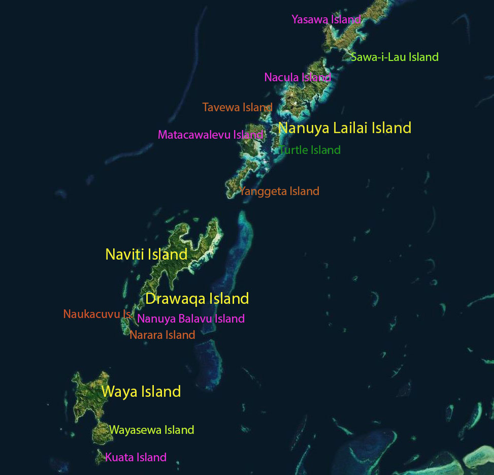
Below, I’ve made a map where where I’ve color coded the names according to the category they fit into. Note that some of the islands have multiple anchorages so while they may get visited by cruisers, not everyone goes to the same places.

Yellow: These are places pretty much visited by everyone. Waya is the gateway to the Yasawas and a convenient stopping point when entering or leaving the area. Nanuya Lailai is home to the famous Blue Lagoon area. Drawaqa Island is very small without much to see but is located close to the channel where the manta rays swim. It’s also an easy dinghy ride to Nanuya Balavu Island and its Manta Ray Island Resort (famous for its festive happy hours and pizza). And large Naviti Island has several anchorages to choose from.
Light Green: These are less visited islands such as Wayasewa, practically attached to more popular Waya. I also put Sawa-i-Lau in this category because while everyone would like to go there and see its famous cave, it’s out of the way, one needs to get through rather windy channel to get there, and it can get unpleasant in the anchorage if the wind picks up. So while many cruisers may plan to go, not that many people actually make it up there.
Purple: While it may be possible to anchor at these islands, they are more off the beaten track and far less visited. Nanuya Balavu Island, home of the Manta Ray Island Resort, is located on a rather shallow channel so most cruisers prefer to tuck behind nearby Drawaqa. Kuata Island is one of the three in the Waya island group. I’ve heard of people snorkeling and diving here but we’ve never tried it.
Nacula Island has a couple of anchorages, but many cruisers consider the Blue Lagoon area as far north as they care to go so don’t venture up to it. Yasawa is the northernmost island in the group and while technically if one goes to Sawa-i-Lau they are also anchored off Yasawa, the reality is people go there to see Sawa-i-Lau. Only a few people we know have ventured further north to the top of Yasawa. Matacawalevu Island is seldom visited by cruising yachts, but people do take their dinghies over (from the Blue Lagoon) to visit a particular garden market. We actaully managed to anchor on the other side of it specifically to visit a resort on Yanggeta Island.
Green: There is only one green name on this list: Turtle Island. It is home to a private and exclusive resort—visitors are not welcome.
Reddish Brown: These islands essentially have no anchorages for any but, in a few cases, very determined shallow draft boats. These include Narara Island, Naukacuvu Island, Yangetta Island, and Tavewa Island.
