
November 7, 2015
…Update, November 9, 2015…
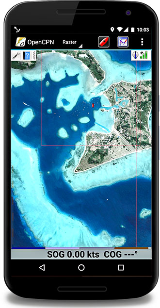
This makes the rest of this post pretty much irrelevant. I’ve been hearing about openCPN for Android for a while now, and what I’ve heard are mixed reviews. Evi on Frieda sent us an email yesterday telling us she’s been using it and it works well. I installed it today and I think it’s great. I’ve got the CM93 charts loaded along with all of our Western Fiji KAP files, waypoints and routes and it does everything I want.
Be careful: There are two openCPN apps in the Google Play Store. One is free, one is about US $10. I went with the paid one. It’s created by some of the same people that have made substantial contributions to the PC version. It doesn’t seem like the free version is as well developed. Besides, it’s nice to support some of the folks behind openCPN.
Now, on to the irrelevant stuff, just in case you’re bored!
A recent conversation on the Pacific Puddle Jump Yahoo group peaked my interest about options for a copy of our nav station computer display in the cockpit – particularly to allow us to use satellite KAP files for real time navigation. One such suggested option was a program/app combination called Vectir.
We’ve been using satellite KAP files on our Android phone for a while now. To do this, we’re using an Android app called Marine Navigator. This app allows us to load KAP files made with GE2KAP or my favorite KAP maker, Chartaid. The downside of this approach is that it’s tedious and time consuming to load the KAPs on my phone, and they use a lot memory. I’d love to be able to display the KAP files on my Simrad chartplotter, but since that doesn’t seem possible (Thanks Simrad – is that really asking too much!?), I might settle for a remote view of our nav station computer which runs openCPN, can receive NMEA data from our boat, and happily displays satellite KAP files.
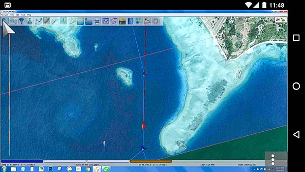
I installed Vectir on our phone and our boat PC and had a chance to try it out on the short trip out to Musket Cove yesterday. It works!
To get it to work, I had a couple of struggles. (By way of background, I’m a techie but I’m not particularly good with networking, and I hate Bluetooth.)
That said, my first try was to use Bluetooth, even though I had my doubts about how fast and smooth it would work and since music over Bluetooth cuts out at the forward part of the cockpit, I doubted the range would be sufficient to get us to the wheel. But still… worth a try.
First, for a Bluetooth connection, the computer and phone have to be paired. That was only slightly confusing and at first, seemed to work. Then the computer just kept installing the same drivers over and over and I could never get Vectir to connect. Maybe I brought this failure on myself? I never really expected it to work.
On to WiFi. That worked without a problem, but by accident. The help files with Vectir don’t impress me, but buried in there, it does say that the devices must be connected to the same network. Ours were as they were both connected to our Vodafone Pocket WiFi device for internet access. With that happy accident, setup was easy and Vectir worked well.
I have since played with trying to connect without using the Pocket WiFi device. First I tried setting up an ad hoc network on my computer. Remember, I said I wasn’t good with networking? I quickly gave up, without success.
We have a small WiFi router we use on the boat with our amplified WiFi antenna. After connecting both our phone and computer to that router, Vectir worked fine, though for some reason, it is a little slower than with the Vodafone Pocket WiFi device.
Keep in mind that the router or Pocket WiFi device doesn’t need to be connected to the internet. The only requirement is that the computer and tablet or phone both be connected to the same network.
Cautionary “no internet” tale: A brief message popped up on my Android phone saying something about no internet access. I ignored it. I couldn’t connect with Vectir. I looked more closely at the message and there was an “ignore and stay connected” option. Once I clicked that, everything worked fine.
I’m sure there are other ways to set up a suitable network without one of these routers, but for me, now that it’s working, I ain’t gonna fix it!
Here’s a bit of an aside. For the satellite images to have maximum value for us, we need to see the boat’s position on the satellite image in real time. On Legacy, we have a NMEA 2000 data buss. I’ve been struggling a bit with getting that data into the computer. I could have used a Actisense NGT-1 gateway, but I didn’t have one. I did have a Simrad AT10 Simnet (NMEA 2000) to NMEA 0183 interface. I brought the resulting NMEA 0183 data into the computer using a RS232 to USB converter cable. Whew! It’s not perfect, and there’s some data that isn’t brought across, or is in a non-compatible format, but it gets us what we need (speed, position, course, depth, some wind info and some other miscellaneous data).
There’s another way (in fact, there are probably lots of other ways). SEAiq is an iPad app that allows you to use KAP files. It seems like a pretty good solution. I don’t use it for the following reasons:
- To get the KAP files in and out, you have to use iTunes. I hate iTunes and the way it can randomly erase data and apps.
- Our iPad is hardly bright enough to use in the cockpit. The Nexus 6 phone we bought has a very bright AMOLED screen and it’s barely bright enough for cockpit use.
I’d love the have a display that’s larger than our 6″ Android phone. Maybe a Android tablet? It too, would have to have a very bright AMOLED display to make it work for us.
Conclusion:
I think I’ll keep using this setup. I love the satellite KAP files for hunting around for a spot to anchor amongst the bombies. On our trip here, we had to divert for a small freighter as we entered a channel. I was able to see with a glance at the satellite image that we had room to do so. -Rich


